 Idaho Annual
Rainfall and Climate Data, see below for individual
cities
Idaho Annual
Rainfall and Climate Data, see below for individual
cities
Idaho Annual
Rainfall and Climate Data, see below for individual
cities
Idaho city precipitation totals
| City |
Avg Annual Precip |
Avg Annual Snow |
Avg. days of Precip | Avg # snow days | Avg # thunderstorm days | Avg # hail days |
Avg # severe thunderstorm watches per year |
Avg # tornado watches per year |
# of tornadoes reported in county, 1960-2010 |
| Boise | 12.19 | 20.4 | 90 | 55 | 10 | 2 | 0 | 1 | 0 |
| Lewiston | 12.74 | 15.7 | 103 | 44 | 27 | 0 | 0 | 1 | 3 |
| Pocatello | 12.58 | 42.0 | 96 | 81 | 24 | 1 | 0 | 2 | 6 |
|
|||||||||
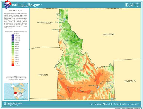
Idaho Precipitation Records
- Driest location ranked by lowest annual average precipitation: Grand View, southwestern Idaho, 7.11"
- Wettest location ranked by highest annual average precipitation: Burke, northern Idaho, 48.87"
- Snowiest location ranked by highest annual average snowfall: Mullan Pass, northern Idaho, 283.5"
- State precipitation record for 24 hours - Rattlesnake Pass, northern Idaho, 11/23/1909, 7.17"
- State precipitation record for 1 year - Roland, northern Idaho, 1933, 81.05"
- State snowfall record for 24 hours - Sun Valley, central Idaho, 2/11/1959, 38.00"
- State snow record for 1 season - Roland, northern Idaho, 1949-1950, 441.8"
- On 1/03/1961, a three day long ice storm hit northern Idaho, producing an accumulation of ice eight
inches thick, a U.S. record
- Floods in Idaho occur most often during the period of seasonal snowmelt in spring, particularly in April
and May. A few areas in the State are actually flooded or threatened by floodwaters nearly every
year. These areas include the Kootenai River valley and in the vicinity of Bonners Ferry. Another area is
the Snake River upstream from Idaho Falls in the areas of Roberts and Menan
- Idaho temperature averages and extremes, precipitation and temperature data for all U.S. states and
interesting Top 10 U.S. climate extremesData sources: National Climatic Data Center, Severe thunderstorm / tornado watch data
period is 1999 - 2008, NOAA Storm Prediction Center, Tornado climate data - NOAA Storm Prediction Center State lightning flash density average - 1997-2011, Vaisala
 Custom Search
|