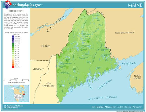
Maine Annual Rainfall and Climate Data, see below for individual cities 

 Maine Average Annual Precipitation

Maine city precipitation totals

City

Avg Annual Precip

Avg Annual Snowl

Avg # days of Precip

Avg # thunderstorm days

Avg # hail days

Avg # severe thunderstorm watches per year Avg # tornado watches per year # of tornadoes reported in county, 1960-2010
Augusta 41.23 78.1 130 30 1 0 4 8
Caribou 37.44 111.3 161 21 1 0 2 20
Portland 45.83 70.0 129 10 0 0 6 7
  • Maine Annual Precipitation Average - 42.28 inches, 23rd wettest state in the U.S. 
  • Maine Tornado Average -  1.8 per year -  39th most in the U.S. 
  • Largest reported Tornado in Maine from 1950-2011, 8/21/2009 - 700 yards / .39 miles wide
  • Average time of occurrence of reported Tornadoes in Maine from 1950-2011 - 3:37 pm
  • Maine Annual Lightning Density - 1.5 flashes per square mile - 43rd highest in U.S.
  • Record Driest year in Maine from 1895-2012 - 2001, avg precipitation 29.61 inches 
  • Record Wettest year in Maine from 1895-2012 - 2005, avg precipitation 61.12 inches 

Maine Precipitation Records

  • Driest location ranked by lowest annual precipitation: Presque Isle, northeastern Maine, 35.27"
  • Wettest location ranked by highest annual precipitation: Acadia National Park, southern Maine, 57.30"
  • Snowiest location ranked by highest annual average snowfall: Rangeley, western Maine, 118.0"
  • State precipitation maximum for 24 hours - Saco, southwestern Maine, 10/21-22/1996, 19.19"
  • State precipitation maximum for 1 year - Brunswick, southwestern Maine, 1945, 75.64"
  • State snow maximum for 24 hours - Orono, central Maine, 12/29-30/1962, 40.0" 
  • State snow maximum for 1 season - Long Falls Dam, western Maine, 1968-1969, 238.5"
  • Maine has the lowest average number of days per year with thunderstorms east of the Rocky Mountains
  • Average monthly precipitation in Maine is between three and four inches, with November being the wettest month and February the driest month 
  • Maine temperature averages and extremes, precipitation and temperature data for all U.S. states and interesting Top 10 U.S. climate extremes

Data sources: National Climatic Data Center, Severe thunderstorm / tornado watch data period is 1999 - 2008, NOAA Storm Prediction Center, Tornado climate data - NOAA Storm Prediction Center, State lightning flash density average - 1997-2011, Vaisala