Rhode Island Annual Rainfall and Climate Data, see below for individual cities 


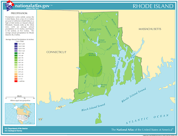
Rhode Island city precipitation totals

City

Avg Annual Precip

Avg Annual Snow 

Avg. days of Precip

Avg # thunderstorm days

Avg # hail days Avg # severe thunderstorm watches per year Avg # tornado watches per year # of tornadoes reported in county, 1960-2010
Block Island 39.79 20.5 108 29 0 0 3 0
Providence 46.45 36.5 124 21 1 0 6 6
  • Rhode Island Annual Precipitation Average - 47.98", 13th wettest in the U.S.
  • Rhode Island Tornado Average - 0.1 per year - 49th most in the U.S.
  • Largest reported Tornado in Rhode Island from 1950-2011, 8/8/1986 - 1,000 yards / .56 miles wide
  • Month with highest number of reported Tornadoes in Rhode Island from 1950-2011, August - 7 tornadoes
  • Average time of occurrence of reported Tornadoes in Rhode Island from 1950-2011 - 2:41 pm
  • Rhode Island Annual Lightning Density - 2.4 flashes per square mile - 42nd highest in U.S.
  • Record Driest year in Rhode Island from 1895-2012 - 1965, avg precipitation 27.59 inches 
  • Record Wettest year in Rhode Island from 1895-2012 - 2011, avg precipitation 59.80 inches

Rhode Island Precipitation Records

  • Driest location ranked by lowest annual average precipitation: Block Island, southern Rhode Island, 39.79"
  • Wettest location ranked by highest annual average precipitation: North Foster, western Rhode Island, 53.17"
  • Snowiest location ranked by highest annual average snowfall: North Foster, western Rhode Island, 55.5"
  • State precipitation record for 24 hours - Westerly, southwestern Rhode Island, 12.13"
  • State precipitation record for 1 year - Kingston, southern Rhode Island, 70.21
  • State snowfall record for 24 hours - North Foster, western Rhode Island, 2/8-9/1945, 34.0"
  • State snow record for 1 season - North Foster, western Rhode Island, 129.1"
  • Historic flooding occurred in Rhode Island during March 2010. 16.32" of rain fell on Providence, which is the 
    most rain recorded in any month, beating the previous record of 15.38" set in October 2005. The Pawtuxet
    River flooding exceeded all-time records, which date back to 1939
  • Rhode Island temperature averages and extremes, precipitation and temperature data for all U.S.states and
    interesting Top 10 U.S. climate extremes

Data sources: National Climatic Data Center, Severe thunderstorm / tornado watch data period is 1999 - 2008, NOAA Storm Prediction Center, Tornado climate data - NOAA Storm Prediction Center, State lightning flash density average - 1997-2011, Vaisala