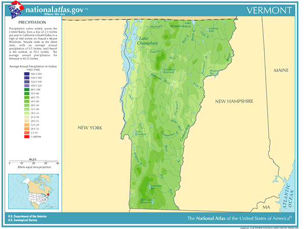
 Vermont
Annual
Rainfall and Climate Data, see below for
individual
cities
Vermont
Annual
Rainfall and Climate Data, see below for
individual
cities
Vermont
Annual
Rainfall and Climate Data, see below for
individual
cities
Vermont city precipitation totals
| City |
Avg Annual Precip |
Avg Annual Snow |
Avg. days of Precip |
Avg # thunderstorm days |
Avg # hail days | Avg # severe thunderstorm watches per year | Avg # tornado watches per year | # of tornadoes reported in county, 1960-2010 |
| Burlington | 36.05 | 79.0 | 154 | 22 | 1 | 0 | 6 | 4 |
|
||||||||
Vermont Precipitation Records
Virtually the entire State received over 6 inches of rain. Torrential rains, up to 15 inches in the higher elevations, sent
streams on a rampage devastating the Winooski Valley. Flooding claimed 200 lives and caused 40 million dollars damage
snowfall recorded there. It was the greatest March snowstorm ever, and the snowfall on March 6th of 17.5 inches
demolished the single day snow record in Burlington of 8.5 inches.
Top 10 U.S. climate extremesData sources: National Climatic Data Center, Severe thunderstorm / tornado watch data period is 1999 - 2008, NOAA Storm Prediction Center, Tornado climate data - NOAA Storm Prediction Center, State lightning flash density average - 1997-2011, Vaisala